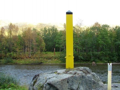
Russian survey crews have been out gathering data this summer that will be used to “re-adjust” parts of their northern border with Norway that literally have washed away in recent decades. After more than a year of diplomatic tension between Russia and Norway, the border definition project appears to be proceeding agreeably.

It’s the first time since 1947 that the border between Norway and Russia is being adjusted, and Norwegian Broadcasting (NRK) reports that it’s long overdue. A post-war border agreement called for a review of the border itself every 25 years, since much of it runs through rivers and marshes that are constantly shifting. It’s taken 68 years, though, to get around to carrying out the task.
Some might view that as a sign of the so-called “special relationship” and friendly ties between Norwegians and Russians in the northernmost parts of both countries. No one seems to have felt an urgency to address the issue, but now they are. Some parts of the Pasvik River are no longer navigable on the Norwegian side, and it’s in both countries’ best interests to set things straight.
The Arctic border between Norway and Russia stretches for nearly 200 kilometers from Norway’s Grense Jakobselv in the north, site of an historic church, to Nyrud in the south. Pasvikelva, the river flowing through much of the area, has moved with the flows of nature, the seasons and the decades. With the border running right through the river, it’s time to officially determine where the border lies now, and stake it out.
“We’re not talking about moving the border, just adjusting it so that the maps and the terrain hang together,” Ulf Mathisen, a Norwegian border inspector, told NRK while riding on a rib boat near Novatun, in the upper Pasvik Valley south of Kirkenes. Russian surveyors were on another raft, equipped with sonar and taking readings as they drifted along unusually calm waters on an unusually sunny day last week.

NRK’s nightly national newscast Dagsrevyen carried a scenic account of the operation, in which both Norwegian and Russian surveyors and border authorities are cooperating and were interviewed as they worked together on the project.
NRK reported how the history behind the shared border goes back to 1826, but after Russia’s defeat in World War I, the area east of Kirkenes, Petsamo, was transferred to Finland in 1920. NRK noted that when Russian Soviet troops marched into Norway’s northernmost county of Finnmark towards the end of World War II and liberated the area from its Nazi German occupiers, the Soviet Union took back Petsamo and several other portions of Finland. The Soviets withdrew from Norway, however, and the current border was firmed through the agreeement in 1947.
Not much more happened during the Cold War, which was followed by the disintegration of the Soviet Union. Now the river has changed course so much that it’s no longer possible to operate a boat on the Norwegian side of the border that runs through the river. Stakes in the water have denoted the border, and boats have been allowed to cross into Russian territory where they can’t sail on the Norwegian side. But Mathisen noted that it’s not allowed to stop, or fish, in the Russian waters.
Norwegian officials are supporting the Russian surveyors with equipment and staff, showing them where the river is navigable. Aerogeodezia, the Russian mapping agency, is charting the river bottom, with the aim of moving the border to areas of the river that are the deepest. Denis Fedorov, a Russian chief engineer working on the project, said the border readjustment will benefit both Norway and Russia.
“It will make the job easier for both the Norwegian and Russian border patrol, when the border runs where it was supposed to,” Fedorov told NRK. It’s mostly Norwegians who use the river and the Norwegians who experience illegal border crossings, he said, adding that “the Norwegian border patrol is much more active on the river than the Russians.”
The survey work will be finished this autumn, and then foreign ministry negotiators from both sides will sit down and actually draw the new border. The goal is that neither country will lose any territory.
newsinenglish.no/Nina Berglund

