As more homes and buildings were lost on Thursday in a “catastrophic” landslide northeast of Oslo, questions were flying over why homebuilders were allowed to develop residential communities on kvikkleire. That’s the clay-like ground that suddenly gave way before dawn on Wednesday, and a hydrologist claims he warned local officials if its potential instability as early as 2008.
Steinar Myrabø wasn’t the only one to warn about erosion problems, reported Norwegian Broadcasting (NRK) on Thursday afternoon. Norges Geotekniske Institutte (NGI) also categorized the area as a high-risk zone and urged “supplemental examinations in zones in the highest risk class” and in areas of lower risk. Reports to that effect were filed between 2003 and 2005, even earlier than Myrabø’s warning.
The area in question is known as Nystulia in Gjerdrum township, just south of the small town of Ask. It was targeted for residential development and local newspaper Ullensaker Eidsvoll Blad (UEB) reported in 2008 how Myrabø “feared serious landslides if nothing was done about erosion problems near the new planned housing project Nystulia.”
NRK was among Norwegian websites running facsimiles of the 12-year-old newspaper article, in which Myrabø described the ground under the residential area as “stable enough … but just below it, it’s dangerous. The area consists of (the clay-like ground) and the whole slope can slide out. If that happens, houses will be affected.”
Drainage problems led to erosion
Myrabø was also leader of the local chapter of the environmental organization Naturvernforbundet (Friends of the Earth), which often opposes development of open land in principle. In this case, Myrabø’s warnings 12 years ago are almost eerily prescient, but seem to have been ignored.
He was worried at the time that development of the area already underway was causing drainage problems, not least after a creek running through Nystulia had been re-directed into pipes and lots of trees had been cleared to make way for housing sites.

“When you remove the forest that has absorbed water, there’s more water that needs to be drained,” Myrabø told UEB in 2008. That in turn led to flooding, which set off erosion and also damaged pipes meant to redirect the creek. He added that “nothing of what I’ve recommended has been followed.” As long as 12 years ago, the newspaper article shows how he urged Gjerdrum’s technical and building officials to follow up and tighten regulations “immediately, before the consequences (flooding at the time) become even greater.”
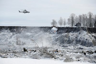
No one, including Myrabø today, knows what actually set off the landslide that has forced the evacuation of as many as 1,500 residents, destroyed more than a dozen homes and left 10 residents still unaccounted for by New Year’s Eve. Prime Minister Erna Solberg has called the landslide “a natural catastrophe,” while builders insist they followed all local regulations as the housing development spread, and have claimed they relied on geologists’ and technicians’ advice.
“I only know that (Gjerdrum officials) did not follow up on the warnings they received at the time,” Myrabø told NRK on Thursday.
Mayor: ‘We’ve been encouraged to build more homes’
Gjerdrum Mayor Anders Østensen of the Labour Party claims that local officials have paid lots of attention to the ground quality in the area, noting how it can also be stable. All building plans were sent to professional authorities, “and we listened to all contributions from the geotechnical milieu and have never challenged their comments,” Østensen told NRK.
“We are quite sure we have done what we were supposed to do,” he said, even as the search for more survivors continued on Thursday with no results. “We’ve been encouraged to build new housing, that’s why a lot has been built here in Ask.” The township’s own maps, however, show Ask as a high-risk area for mud slides, with the area where the slide occurred ranked as “risk level 5,” the highest of all. Developers nonetheless received approval to start building there in 2005.
NGI (the geotechnical institute) will go through its past 10 years’ worth of examinations of the area, “as soon as this acute phase is over,” said NGI engineer Guro Grøneng. “Then it will be critical to evaluate the reasons this has happened. It’s natural to think that erosion around the creek is one of the things to be evaluated.”
NewsInEnglish.no/Nina Berglund